BEEPTHROATPublic records on the BeltLineThe Archive

Before there was a trail, there was a vision.

Most Atlantans know the BeltLine as a trail. Some know it as a parks project, others as a redevelopment engine. But none of those things were the vision. The BeltLine was conceived as a complete public realm, a connected system of transit, parks, trails, neighborhoods, and civic destinations that would reshape how an entire city moved and grew.

Drawn from two foundational documentsGravel, 1999 · Garvin, 2004The standard ↓

Long before construction began, two documents defined that vision. Together they describe something far more ambitious than a recreational trail. They describe a new way for Atlanta to grow.

The Emerald Necklace: Ryan Gravel's original vision of a continuous ring of parks, trails, and light rail around Atlanta's urban core
The original vision: a continuous 22-mile ring of light rail, trail, and parkland encircling Atlanta's urban core, connecting the neighborhoods around it.
What most people think it is

A trail.

A linear park to walk, run, and bike.

What others think it is

A parks project.

Green space stitched across the city.

Or an economic one

Redevelopment.

A driver of property value and growth.

Where the vision was written down

Two documents defined the BeltLine before a single foot of trail was built.

One was a graduate thesis that proposed the idea. The other was a comprehensive framework that scaled it into a plan for the whole city. Read together, they are the original blueprint.

Cover of Ryan Gravel's 1999 Georgia Tech thesis, Belt Line - Atlanta
The proposal
1999

By Ryan Gravel · Georgia Tech graduate thesis

Belt Line - Atlanta: Design of Infrastructure as a Reflection of Public Policy

Gravel proposed transforming Atlanta's underused freight-rail corridors into a transit-oriented loop connecting the neighborhoods around the urban core, the idea that spurred the entire project.

Core argument: infrastructure determines how cities develop. Build the right kind, and you reconnect the city.

View the original (PDF)
Cover of Alexander Garvin's 2004 framework, The BeltLine Emerald Necklace
The framework
2004

By Alexander Garvin · planning framework

The BeltLine Emerald Necklace: Atlanta's New Public Realm

Garvin expanded the concept into a comprehensive framework for Atlanta's future growth, a unified civic system of parks, trails, transit, and destinations organized around the loop.

Core question: what if Atlanta could finally build the public realm that great cities possess?

View the original (PDF)

Gravel's argument: a different kind of infrastructure

Infrastructure determines how cities develop.

That was Gravel's central, almost deceptively simple claim. Atlanta had already lived it twice, and could choose to live it a third time, deliberately.

Early 20th century

Streetcars

Built the core

Streetcar lines created Atlanta's first walkable neighborhoods, clustered around the routes people rode.

Mid–late 20th century

Highways

Pushed growth outward →

Freeways enabled decades of suburban expansion, dispersing the region and hollowing the center.

The 21st-century choice

The BeltLine

Pulls growth ← inward

Transit infrastructure, designed deliberately, could reverse those trends, directing growth inward around a connected urban core.

The BeltLine was never proposed as an amenity. It was proposed as a piece of city-building infrastructure, meant to encourage density, support transit, reduce automobile dependence, and strengthen Atlanta's center rather than continue to disperse it.

When the design of public infrastructure directs private action, architecture and planning become political.Ryan Gravel, Georgia Tech thesis · 1999

Garvin's question: the public realm Atlanta never had

Great cities are remembered for their public spaces.

Garvin's framework opened with a comparison. The cities we hold up as great are defined by the civic spaces they share, and Atlanta, despite decades of growth, had never built a comparable framework of its own.

New York

Central Park

A civic heart at the center of the city.

Chicago

The Lakefront

Miles of continuous public parkland.

Boston

Emerald Necklace

Olmsted's connected chain of parks.

Atlanta

the missing piece

No comparable public framework. The BeltLine was meant to become it.

Garvin described the BeltLine as a once-in-a-lifetime opportunity, a chance to transform a largely abandoned ring of railroad corridors into a unified civic system connecting neighborhoods, destinations, transit, and open space. The goal was not simply to add parks. It was to create a structure around which Atlanta itself would grow.

The plan: the Emerald Necklace

A continuous loop of trail and transit, strung with civic “Jewels.”

At the center of Garvin's vision was a continuous trail paired with transit service, connecting neighborhoods to one another and to the destinations along the way. He called the destinations the “Jewels” of the Emerald Necklace, not isolated parks, but regional places linked by trail and transit into a single experience.

22 mi
continuous BeltLine Trail around the urban core
~20 mi
of transit service paired with the trail
46
neighborhoods connected to each other and to destinations citywide
The Jewels
Expanded Parks04
  • Piedmont Park
  • Maddox Park
  • Ardmore Park
  • Enota Park
New Parks04
  • Peachtree Creek Park
  • North Avenue Park
  • Waterworks Park
  • Holtzclaw Park
Mixed-Use Urban Centers05
  • Hulsey Yards
  • Murphy Crossing
  • Boulevard Crossing
  • Simpson Road
  • Bellwood Lake
From the plan

The scale of the public realm

Collectively, these projects would have created more than 1,400 acres of new parkland and over 2,500 acres of connected public realm, not as scattered amenities, but as a single network. The parks were not the destination. The network was.

The parks were not the destination. The network was.

The part that gets forgotten

Transit was the spine of the entire concept.

One of the most striking aspects of the original vision is how central transit was. Garvin repeatedly described the BeltLine not as a trail with transit attached, but as a single integrated system, four parts working as one.

◆ The spine

Transit

Connecting neighborhoods to each other and to MARTA through new transfer points where rail lines crossed the loop.

02

Trails

A continuous path for walking and biking, complementary to transit, never a replacement for it.

03

Parks

The Jewels, regional destinations woven directly into the line.

04

Development

Walkable, mixed-use districts gathered around the transit stations.

Residents would not simply walk or bike the BeltLine. They would use transit to move between parks, neighborhoods, jobs, schools, and entertainment districts, traveling across the city without relying on a car.

CabbagetownPiedmont Parkby transit + trail
West EndVirginia-Highlandno automobile

The trail and transit were designed as complementary systems. Neither was ever intended to replace the other.

The most powerful statement in the plan

It was never really about transit, or parks. It was about identity.

The essence of the original vision

The BeltLine would reorient Atlanta, from a city framed by highways to a city framed by a magnificent public realm.

That sentence captures the whole of it. The BeltLine was never simply a transportation project. It was never simply a parks project. It was never simply an economic-development project. It was all of those things simultaneously, a connected civic framework capable of shaping Atlanta's growth for generations.

The vision in plain English

Strip away the maps and the planning language, and it was remarkably straightforward.

  1. A complete transit loop around the urban core.
  2. A continuous trail system connected to that transit.
  3. Major new parks serving every part of the city.
  4. Walkable, mixed-use districts around transit stations.
  5. Stronger connections between neighborhoods.
  6. Reduced dependence on automobiles.
  7. A public realm capable of defining Atlanta for the twenty-first century.

The promise, and the measure

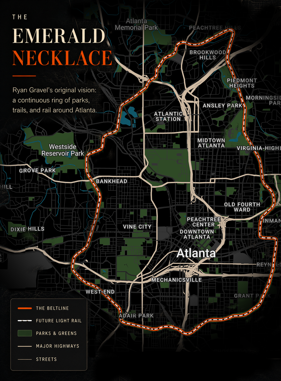
The BeltLine was conceived not as a trail with amenities attached, but as a city-building framework.

The trail, the transit, the parks, and the redevelopment were intended to function as one integrated system. That was the promise. That was the vision.

The standard

This is the standard against which any discussion of the BeltLine's success, or failure, should be measured.

Read next

What was built instead

Part I documents how the voter-approved light rail at the center of this vision gave way to a $3 million driverless-shuttle pilot. Part II traces who governs the nonprofit the BeltLine calls the steward of “the vision.” Measure both against the promise above.

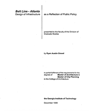
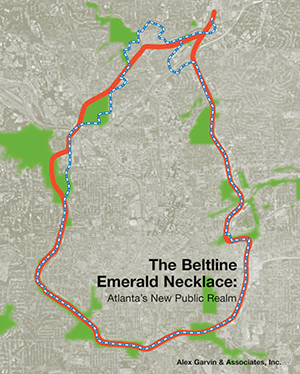
Sources: This page summarizes two foundational documents: Ryan Gravel's 1999 Georgia Tech master's thesis, Belt Line - Atlanta, and Alexander Garvin's 2004 framework, The BeltLine Emerald Necklace: Atlanta's New Public Realm. Figures (22-mile trail, ~20 miles of transit, 46 neighborhoods, 1,400+ acres of new parkland, 2,500+ acres of connected public realm) and the named Jewels are drawn from Garvin's plan.